Key Decisions Before the First Heavy Rain
Summary: Effective drainage begins long before the first trench is dug. Planners must read the ground, keep shelters out of natural flow paths, give runoff a continuous route, protect WASH areas, and assign clear maintenance responsibilities.
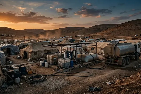
Temporary camps rarely inherit prime real estate. Host governments typically allocate marginal land, such as rocky hillsides, degraded agricultural plots, or low-lying basins. Because the terrain is inherently difficult, the primary goal of site planning is risk reduction and safe movement rather than perfect civil engineering—an impossible standard in emergencies.
Drainage is fundamentally a layout decision. It is not merely a construction task assigned to earthmoving crews after the tents are pitched. Planners sequence the layout by first mapping the macro-drainage corridors across the site. They then align the main access roads parallel to the natural contours. Finally, they slot in the shelter blocks. Drawing a rigid grid over uneven terrain forces water into unnatural paths, inevitably leading to flooded sleeping areas.
Read the Ground Before Drawing Shelter Blocks
A site plan drawn in an office cannot capture the subtle realities of water movement. Field teams conduct transect walks to understand the landscape before plotting a single shelter. These walks typically cover roughly 10 to 15 hectares per day. Timing matters immensely. Teams walk the site during early morning or late afternoon when low sun angles cast shadows that highlight subtle depressions, old stream beds, and historical erosion scars.
Rainwater moves through a camp in distinct phases. It begins as sheet flow across open ground, concentrates into channeled flow along tracks, pools behind raised roads, and ponds around compacted shelter plots. During transect walks, planners look for soil discoloration marks 10 to 30 centimeters above ground level on existing vegetation. These marks are reliable indicators of historical ponding.
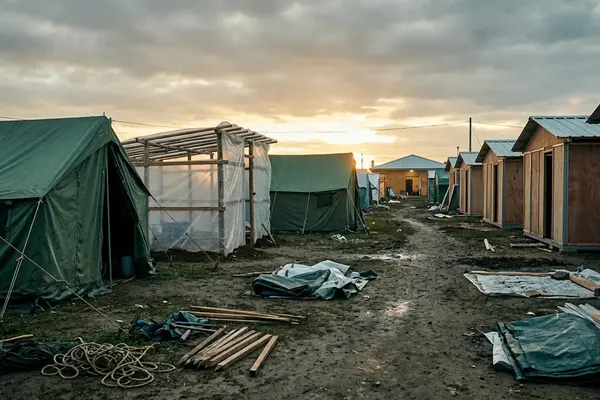
Quick Tip: Mark no-build drainage corridors immediately. If these natural flow paths are not physically cordoned off early, they will quickly be filled with shelters, latrines, storage tents, or informal market stalls.
Shape Roads, Plots, and Drains as One System

Drainage depends entirely on relative elevations. Raised sleeping areas, sloped access routes, and shallow drains must connect seamlessly. If they fight each other, water will pool. In temporary settlements, roads frequently become either unintended drains or accidental dams. Planners must decide which function each route will perform before heavy machinery arrives.
Engineers coordinate road grading and plot leveling simultaneously to achieve an optimal balance. They ensure that the crown of the access road sits higher than the plot edges. Specifically, road crowns are elevated 15 to 25 centimeters above the shoulder. This directs runoff into designated roadside channels rather than allowing it to sheet across the driving surface.
Plot preparation requires equal attention. Shelter entrances should never be placed where runoff naturally crosses the doorway. Plot-level perimeter channels are dug to a maximum depth of about 15 centimeters to catch roof runoff. These small channels must be routed carefully to prevent water from discharging directly into neighboring shelters.
Keep Runoff Away From WASH and Health-Critical Areas
Floodwater is not exclusively a shelter problem. Uncontrolled runoff can undermine latrine pits, contaminate handwashing stations, damage water distribution points, and make clinic access hazardous. Settlement planning and sanitation protection must be coordinated from the very beginning. For foundational principles on this coordination, teams rely on Sphere Handbook guidance on shelter, settlement, WASH, and drainage.
Certified WASH coordinators map the downhill trajectory of all water points and latrine blocks during the initial layout phase. They deliberately route clean access paths on the uphill side of these facilities. Conversely, wastewater drainage channels are positioned on the downhill side to prevent cross-contamination.
Layout priorities dictate strict spatial relationships. A critical rule is maintaining a minimum buffer of around 30 meters between latrine soakaways and primary drainage outfalls. Health posts and bathing areas are placed on elevated, well-draining soil where access remains usable even during sustained rainfall.
Build Drains That Camp Teams Can Maintain
Temporary-camp drainage must be maintainable using available hand tools and local labor arrangements. Oversized ambitions fail quickly if drains cannot be cleaned or if residents block channels to protect their individual plots. Safe disposal routes for removed silt and solid waste must be established before the channels are even dug.
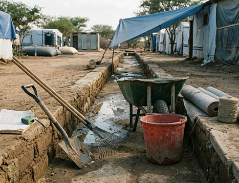
Program evaluation has revealed that initial drainage designs often misjudged field realities. Teams initially considered digging deep, narrow V-shaped trenches to maximize water velocity. They rejected this approach because the steep sides collapsed easily under foot traffic and quickly trapped solid waste. Instead, they switched to a proven approach: trapezoidal channels with 1:2 side slopes. These wider, shallower drains are far more stable and easier to sweep out.
Note: Soil type dictates channel geometry. In sandy soils, unlined channels require wider profiles and gentler slopes to prevent scouring, whereas clay-heavy soils allow for steeper channel banks but require more frequent clearing of standing water.
Maintenance is a continuous operational requirement. Clearing schedules are typically set for every 7 to 10 days during the rainy season to ensure capacity remains open.
Plan for Blockages, Erosion, and Access Failure
Even well-designed systems experience predictable failure points. Drain crossings, culvert inlets, tight bends, and areas beside communal kitchens are notorious for accumulating plastic waste. Intense rain can rapidly convert a shallow channel into a severe erosion cut that threatens shelter platforms or pedestrian routes.
Site planners identify high-risk bottlenecks by mapping where primary drains intersect with heavy pedestrian traffic. At these junctions, they install reinforced crossing slabs. Without these slabs, foot traffic will trample the drain edges, causing blockages that are guaranteed to fail during the next storm.
Redundancy is built into the network through secondary overflow swales. These swales are designed to safely divert and handle bypass water for several hours until maintenance crews arrive. A classic failure case occurs when a primary drain terminates abruptly at a camp boundary road. This causes severe ponding that rapidly undermines the foundations of adjacent perimeter shelters.
Inspect the Camp After Each Storm
Relying on a dry-season site plan during the monsoon is a dangerous gamble. The landscape changes with every major weather event. Maintenance supervisors dispatch inspection teams to verify the integrity of the network. These inspections are conducted within a few hours after a major rainfall event ceases.
Teams start from the highest elevation points of the camp and work downward. They document new erosion cuts, collapsed drain edges, and resident-made modifications. Geolocated photos and field notes are used to update the master camp map.
Post-Storm Rapid Drainage Inspection Checklist
- Check culvert inlets and tight bends for plastic waste blockages.
- Measure ponding depth and duration near latrine pits and water points.
- Inspect trapezoidal channel walls for collapse, scouring, or erosion.
- Verify that access routes to health clinics and distribution centers remain passable.
Scope and Limits of Drainage in Temporary Camps
Surface drainage planning significantly reduces health and safety risks, but it cannot make an inherently unsafe floodplain safe under all storm conditions. Camp administrators must evaluate the site's overall hydrological risk profile continuously. Ongoing multi-year partnerships with local water authorities help establish baseline expectations for seasonal weather patterns.
While field conditions often dictate deviations from standard models, monitoring reports show that local mitigation efforts eventually reach their physical limits. If seasonal river flooding exceeds the network's design capacity—a situation requiring advocacy rather than engineering, administrators must transition to planning for partial camp relocation.
Furthermore, surface interventions have distinct boundaries. Surface drainage planning mitigates rainfall runoff but cannot resolve flooding caused by groundwater upwelling in environments where the seasonal water table rises to within 30 centimeters of the surface. In these extreme cases, site-specific hydrology and local engineering advice will override generic humanitarian guidance.